


Toronto’s TO360 wayfinding system uses a smart evaluation method to apply subjective results in their (successful) business case.
The City of Toronto’s Walking Strategy (2009) set out a goal to “create an enviornment where walking is an appealing, convenient, safe and stimulating experience for residents and visitors”. Eight years later the city is successfully rolling out a multi-modal wayfinding system across the whole city.
City wayfinding systems take many years to develop from an initial idea to full implementation. One of the key persuaders in Toronto was an Outline Business Case created by wayfinding experts Steer.
Steer’s aim was to present a Benefit/Cost Ratio which would give evidence of a high return on investment. In order to be as accurate as possible the study was based on initial forecasts, a pilot project and comprehensive before- and after- market research studies. The challenge, however, of measuring the Benefit/Cost Ratio of a city wayfinding system, is to convert all the costs and all the benefits to the same currency.
“The challenge of measuring the Benefit/Cost Ratio of a city wayfinding system, is to convert all the costs and all the benefits to the same currency” – humantransit.org
For an analysis of city wayfinding potential this would mean applying a dollar value to social and environmental benefit in addition to economic benefit. It would also require scoring subjective aspects, such as the aesthetic value of well designed signage, in monetary terms.
The solution was to use Multiple Account Evaluation (MAE), a system popular in Canada since it was used by the British Columbia government in 1993. MAE enables the combination of qualitative and quantitative assessments of themes from a number of ‘accounts’, in this case:
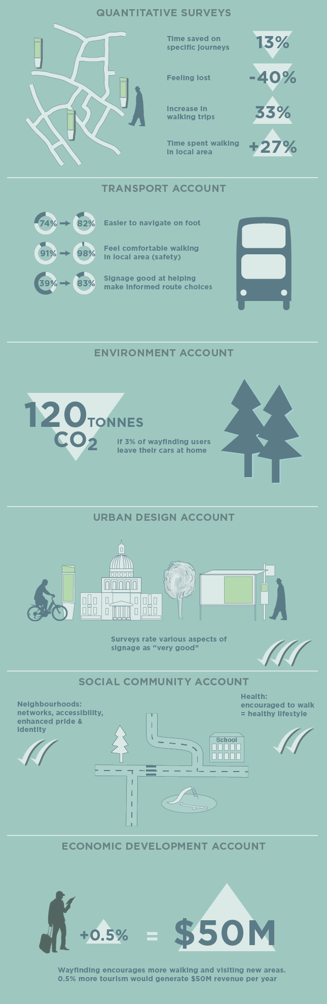
Pre- and post- pilot market research surveys were carried out including 300 intercept interviews, 20 mystery shopping surveys and 10 accompanied journeys. Subjective analysis then received a score based on a matrix combining the number of people or instances affected and the magnitude of the effect (significant, moderate, slight or none).
Steer applied the MAE framework model to rank measures across the six accounts. These measures included assessing to what extent wayfinding signage can:
Surveys showed that pedestrians are more likely to say it was easy to navigate the local area, or that they felt more comfortable walking on foot with the wayfinding signage in place. The perceived accessibility and attractiveness of local amenities was also thought to enhance the pride people have in their own neighbourhood. These results cannot be expressed in terms of dollars. Instead, where a majority of those interviewed described a significant effect, the score given was significant benefit.
Some themes received scores according to the above MAE scale, whereas others received a quantative score in dollar terms. An example of the results are visualised in the accompanying infographic. In this way, financial costs and benefits are just one of many issues to be considered.
The Benefit/Cost Ratio, taking into account the projected costs of developing and maintaing a complete wayfinding system, was 3.7:1. This means that for every dollar invested, $3.7 would be generated for the city. Thanks to the MAE method a wide range of returns on investment were also included which were too subjective to be measured in terms of dollar returns.
Steer’s resulting Outline Business Case was a success. When presented with recommendations for system funding and roll-out it was decided to continue rolling out the system across the whole city of Toronto.