


”Why not just use Google?” – I wish I had £1 for every time I heard that from wayfinding sceptics.
Mobile wayfinding apps like Google, Moovit and CityMapper have changed forever the way people find their way in London. This is not all positive, however, according to research carried out by Transport for London. The study, to evaluate if (and how) Legible London should evolve to meet the times, found that mobile apps are dumbing down how people think about and understand the city.
The following infographic gives an overview of the report findings, describing the advantages and disadvantages of digital vs. printed signage wayfinding:
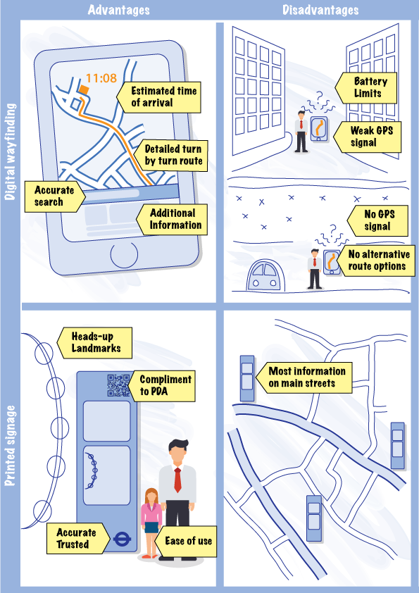
Mobile wayfinding app users seem to be navigating around cities with their heads down. Not only does this mean missing so much of interest, it also leads to a poorer mental image of the surroundings. To mention a few other limiting factors found in the report: wayfinding apps are not ’heads-up’, which is important for orientation; they describe only one walking route option of many; and they miss the opportunity to pick out landmark buildings on the way.
The TfL report recommends that Legible London should continue in its present form, as a system celebrated globally and widely adopted by boroughs and stakeholders. However, it recommends certain areas for technological innovation, including accessibility information, underground exits and live service disruptions.
We would go further to suggest that physical and digital wayfinding options are not mutually exclusive. Technology could be used to enable mobile devices to compliment a fixed sign, adding extra value to the basic essentials. For example near-field communication (NFC) could connect a nearby sign with a mobile device to display a journey plan.
Augmented reality (AR) has been piloted in combination with physical signs, overlaying personalised features (relevant museums, entertainment or shopping content) when a camera phone points at a physical map sign.
Physical signage has clear advantages in terms of ease of use, presenting clear information in the place it is most needed and offering more in terms of the character of a city and what it has to offer. Digital information features live data and a regularly updated basemap. We recommend a cohesive system including both alternatives. One development the near future will certainly offer, is interactive information screens, with a combination of physical and digital signage offering updated information and live data feeds.